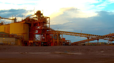
Regis Resources
  • Home
  • About Us
    • About Regis Resources
    • Board of Directors
    • Senior Management
    • Corporate Directory
    • Corporate Governance
  • Projects
    • WA Projects
      • WA Project Map
      • Moolart Well
      • Rosemont
      • Garden Well
      • Erlistoun
      • Collurabbie
      • Satellite Deposits
    • NSW Projects
      • NSW Project Map
      • McPhillamys Gold Project
    • Resources and Reserves
  • Corporate Responsibility
    • Environment
      • Environment
      • Dams and Tailings Management
    • Community Relations
    • Occupational Health and Safety
    • Corporate Policies
    • Sustainability
  • Investors
    • ASX Announcements
    • Reports
    • Presentations
    • Broker Reports
    • Shareholder Centre
      • Shareholder Centre
      • Dividend Reinvestment Plan
      • Annual General Meeting
    • Conference Calls
  • Employment

Moolart Well Gold Mine

Overview

Stage Producing 
Mine Type Open pit 
Mineralisation Laterite & oxide 
Plant type  Crush, grind, CIL 
Throughput  2.9mtpa 
Average grade  0.92g/t gold 
Recovery  >91% 
Ore Reserves 194Koz2
Mineral resources  1.1Moz2
The Moolart Well Gold Mine is located within the Duketon Gold Project, approximately 350 kilometres north, north-east of Kalgoorlie in Western Australia. The Company completed development of the Moolart Well Gold Mine in the September 2010 quarter on time and within budget. 
 
The Moolart Well deposit is a large oxide gold deposit sitting within a deeply weathered Archaean ultramafic-mafic volcanic sequence above the base of weathering at about 70m vertical depth. Primary gold-sulphide mineralisation exists within quartz lodes and alteration zones beneath the weathered zone in fresh rock.
 
The deposit consists of two zones: a flat-lying laterite zone developed in an iron-rich weathering hard cap, and a deeper oxide zone developed in clays. These relationships are illustrated in the cross section below.
 
The laterite zone of mineralisation is covered by 6m of barren colluvial material and extends down to an average depth of 20 metres. Over the known 5km x 1.5km extent of the Moolart well mineralisation, the average mineralised laterite ore thickness is 3.8 metres, and the average colluvial cover is 6.4 metres.
 
The oxide mineralisation extends from beneath the laterite cap at 20m down to the base of weathering at approximately 70m vertical depth. 
 

Download The Moolart Well Cross Section (PDF)

Mining is conducted using truck and shovel excavation methods by Mining and Civil Australia Limited. The plant design is based on a nominal 2.0mtpa throughput utilising a three stage crushing circuit, a scrubber and a single ball mill followed by gravity and carbon in leach circuits.
The Company continues to actively explore within the significant oxide zones to add to the reserve base of the project.
 

Moolart Well Photo Gallery


  • Click to enlarge image Duketon,-June-2010-200.jpg
  • Click to enlarge image Duketon-3-7-2010-005.jpg
  • Click to enlarge image Duketon-3-7-2010-027.jpg
  • Click to enlarge image Duketon-3-7-2010-033.jpg
  • Click to enlarge image Duketon-3-7-2010-049.jpg
  • Click to enlarge image Duketon-3-7-2010-052.jpg
  • Click to enlarge image Duketon-3-7-2010-060.jpg
  • Click to enlarge image Duketon-3-7-2010-067.jpg
  • Click to enlarge image Duketon-3-7-2010-070.jpg
  • Click to enlarge image Duketon-3-7-2010-071.jpg
  • Click to enlarge image Duketon-3-7-2010-076.jpg
  • Click to enlarge image Duketon-3-7-2010-077.jpg
  • Click to enlarge image Duketon-3-7-2010-080.jpg
  • Click to enlarge image Duketon-3-7-2010-081.jpg
  • Click to enlarge image Duketon-3-7-2010-094.jpg
  • Click to enlarge image Duketon-3-7-2010-118.jpg
  • Click to enlarge image Duketon-3-7-2010-121.jpg
  • Click to enlarge image Duketon-3-7-2010-161.jpg
  • Click to enlarge image Duketon-3-7-2010-163.jpg
  • Click to enlarge image Duketon-July-10-158.jpg
  • Click to enlarge image Duketon-July-10-171.jpg
  • Click to enlarge image Duketon-July-10-178.jpg
  • Click to enlarge image Duketon-July-10-202.jpg
  • Click to enlarge image Duketon-July-10-224.jpg
  • Click to enlarge image Lancaster-Laterite-Open-Pit.jpg
  • Click to enlarge image Lancaster-Open-Pit.jpg
  • Click to enlarge image Moolart-Well-Gold-Mine-aerial.jpg
  • Click to enlarge image P8060037.jpg
  • Click to enlarge image P8060038.jpg
  • Click to enlarge image P8060039.jpg
  • Click to enlarge image P8060039A.jpg
  • Click to enlarge image P8060040.jpg
  • Click to enlarge image P8080018.jpg
  • Click to enlarge image P8080019.jpg
  • Click to enlarge image P8080024.jpg
  • Click to enlarge image P8080030.jpg
  • Click to enlarge image P8080031.jpg
  • Click to enlarge image P8080032.jpg
  • Click to enlarge image P8080033.jpg
  • Click to enlarge image P8080034.jpg
  • Click to enlarge image P8080035.jpg
  • Click to enlarge image P8080036.jpg
  • Click to enlarge image P8080037.jpg
  • Click to enlarge image P8080038.jpg
  • Click to enlarge image P8080043.jpg
  • Click to enlarge image P8080044.jpg
  • Click to enlarge image P8080045.jpg
  • Click to enlarge image P8080046.jpg
  • Click to enlarge image pano.jpg
  •  
View the embedded image gallery online at:
http://www.regisresources.com.au/Duketon/moolart-well-gold-mine.html#sigProId4e7ee86e20


  • Privacy and Legal Notices
  • Contact Regis Resources

© 2021 Regis Resources. All Rights Reserved.

Go Top